Garment District Neighbourhood Association
  • HOME
  • ABOUT
  • DEVELOPMENT
    • Ace Hotel
    • King Portland
    • Manga Hotel
    • Waterworks
    • Woodsworth
    • 445 Adelaide
    • 544 King
    • 149 Bathurst
    • 8-18 Camden
    • 39-47 Camden
    • 580 King
    • 590 King
    • 123 Portland
    • 135 Portland
    • 450 Richmond
    • 457 Richmond
    • 520 Richmond
    • 543 Richmond
    • 96 Spadina
    • Nearby >
      • King Toronto
      • The Well
      • 64-86 Bathurst
      • 164 Bathurst
      • 415 King
      • 663 King
      • 241 Richmond
      • 464 Queen
      • 101 Spadina
      • 147 Spadina
      • 424 Wellington
  • INITIATIVES
    • ONTARIO LINE
    • ST ANDREWS PLAYGROUND
    • YMCA
    • CITY PLANNING
  • RESOURCES
    • LINKS
    • HOW TO

Opportunity to Create New City Park at Spadina and Adelaide West

1/5/2022

0 Comments

 
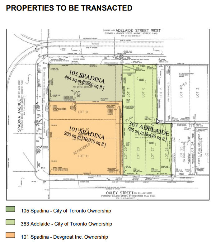
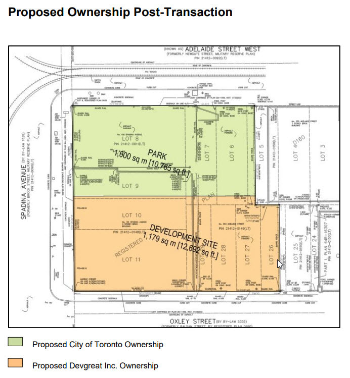
Remember this THIS PROPOSAL involving two City-owned properties at 105 Spadina Avenue and 363 Adelaide Street West, and the privately owned property at 101 Spadina Avenue? The City-building benefits of this transaction are to create a new 1,000 m2 public park, to significantly increase public parking on this site and to generate additional funds to be used for affordable housing.  A successful transaction would look like this:
Picture
Picture
This was in July 2020 ... so I asked Anthony MacMahon about the status of this proposal.  This is his encouraging response:
It's still a part of the parks and public realm strategy: LINK HERE
The adjacent APPLICATION AT 101 SPADINA was submitted to the city in December.  [VE: Supporting documentation not available as of this writing]  Staff in Community Planning should be delivering a preliminary report to TEYCC in the next few months, and there'll be a community consultation scheduled around that time. While the final park design won't come until later, I anticipate that there'll be preliminary park work shown at that consultation, as some of the park will be determined by the articulation of the building and the parking garage underneath.
0 Comments

Major Transit Station Areas

1/2/2022

0 Comments

 
New initialisms have crept into our development vocabulary.

​Major Transit Station Areas (MTSAs) and Protected Major Transit Station Areas PMTSAs) are the subject of a Public Meeting to be held by the Planning and Housing Committee on January 12, 2022 at 10:30am 

The Province of Ontario needs the City to review our Official Plan by summer 2022.  This update will help us prepare for long-term growth over the next 30 years.  Toronto is expected to grow by 700,000 people and more than 450,000 jobs by 2051.  Now to the business of planning how to accommodate that growth. 
One approach is to place growth within walking distance of rapid transit stations.  It means compact, walkable areas with a diverse mix of uses and incomes, at densities that support transit ridership. This allows people to access public transit quickly and conveniently from the places they live, work, learn, shop, and play. Toronto has more than 180 potential Major Transit Station Areas (MTSAs) which could be designated for transit-oriented development. These are areas within an approximate 10-minute walk (500–800 metre radius) of a transit station (existing or planned). 
What are these 180 potential MTSAs?  Here is the LIST.  What data are associated with each of the MTSAs?  You might be curious to scroll through this DOCUMENT and see what metrics are assigned to each of these downtown MTSAs on TTCs subway line one. 
For example:
  • Existing and permitted development within the Protected Major Transit Station Area – Spadina Station is planned for a minimum population and employment target of 300 residents and jobs combined per hectare.
  • Existing and new development within the Protected Major Transit Station Area – College Station is planned for a minimum population and employment target of 1200 residents and jobs combined per hectare.
  • Existing and new development within the Protected Major Transit Station Area – King Station is planned for a minimum population and employment target of 2000 residents and jobs combined per hectare.
If you are interested in learning more, maybe getting involved, the City has produced this PROMO, this GUIDE and this WEBSITE.

0 Comments

Mandatory pre-application consultation proposed for development cycle

9/2/2021

0 Comments


As the City comes back to life, the GDNA comes out of hibernation with battles to fight, meetings to attend, activities to document.  So let's start here:

A virtual city-wide Community Consultation meeting is scheduled to address ​improvements to the early stages of the development review process through amendments to both the Official Plan and the Municipal Code that require MANDATORY pre-application consultation. 
Click HERE for details and instructions for participation.
Click HERE for the Proposals Report. 
Click HERE for the 94-page End-to-End Review of the Development Review Process 
0 Comments

Watermain Replacement - Richmond Street West

7/27/2019

0 Comments

 
It has begun already … replacement of a 143-year-old watermain along Richmond Street West, along with a partial reconstruction of some sidewalks and restoration of the road and cycle track.
Picture
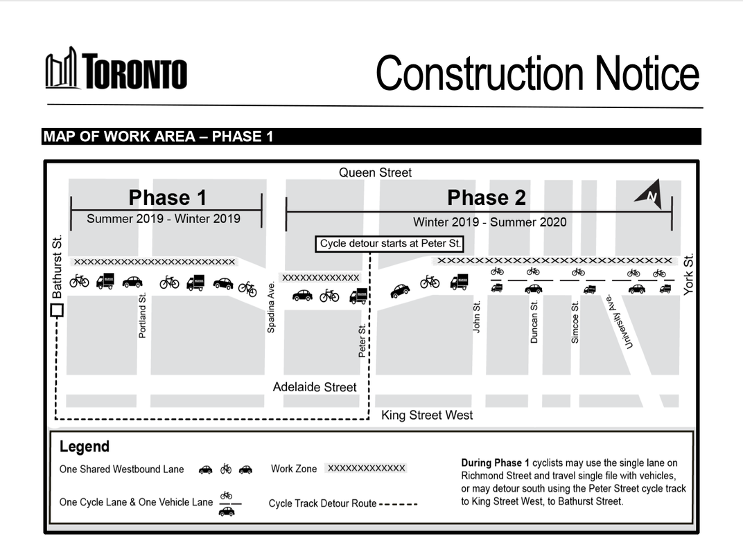
For additional detail click HERE. 
0 Comments

Graffiti Alley Project

4/18/2019

0 Comments

 
The alleyway just west of Portland running north-south from Queen West to Rush Lane is soon to have a “make-over”.  With input from various players … City staff, electricians, commissioned architects and sculptors, the Queen West BIA, adjacent residents/businesses, Project Laneway, the GDNA and graffiti artists … plans can be viewed here:  

If you zoom in on the “landscape plan” you will note:
1.Paving, with good drainage construction, in an irregular weave pattern.
2.Lighting on poles.  The diagram shows 4, but my notes say 5.
3.Metal (bronze?) inlays.  TBD but I like an idea proposed by Allan (aka Uber500) that the inlays should contain the “handles” of the Toronto graffiti artists who have made the Alley what it is.
4.One bollard at the south end and removal of a curb cut at the north end of the lane to prevent vehicular access.
5.Two light pillars, one on Queen Street and the other in Rush Lane, denoted by triangles on the diagram, within sculpted steel assemblies.

As for the practical aspects, the BIA will be responsible for maintenance of the laneway (the City will add a line item in the BIA's budget).  the BIA will have access to electrical outlets on the lighting poles should they want to use the laneway for special events.  Original architectural renderings included seating in the laneway but local businesses said they would prefer to pull out temporary tables and chairs for occasions requiring such.

This “no name” laneway needs a name.  I have confirmed that suggestions collected in 2017 have not been lost … so maybe this laneway will not be nameless for long.  As for timing, the City and the BIA want to move quickly but the project will probably not be completed before next spring. 

One of the goals of this project was to set a “standard” for other lanes going forward.  So I expect we will be asked for feedback when this phase of the project is compete.
0 Comments

Brant Street One-Way Northbound

10/31/2018

1 Comment

 
On July 4, 2018 the Toronto and East York Community Council adopted item TE34.176 with the effect of converting the block of Brant Street between Adelaide Street West and Richmond Street West to one-way northbound vehicular travel. This change helps to accommodate the increasing level of demand for curbside activities in the neighbourhood by permitting one lane of traffic to continue unobstructed around vehicles engaged in deliveries or passenger pick-up and drop-off. Brant Street is a short local road but because it connects Richmond Street West and Adelaide Street West, the City's busiest cycling routes, it is an important link for safe cycling in the neighbourhood.
On July 23, 2018 City Council adopted item MM44.110.  Transportation Services staff reviewed the dimensions of Brant Street and determined that a southbound contra-flow cycling lane can be installed without displacing any existing lanes of traffic. There is a No Stopping regulation already applied to the affected curbside due to its adjacency with St Andrew's Playground and numerous curb cuts, so the contra-flow lane will not affect any parking spaces.
Expect changes to be in place by summer 2019.
Picture
1 Comment

All-Candidates Meeting for City Councillor in Ward 10

10/2/2018

0 Comments

 
There are 14 candidates running for the position of Councillor in Ward 10 (Spadina - Fort York) in the municipal election on October 22nd.  The GDNA and seven other resident associations who call Ward 10 their home have organized an All-Candidates meeting on Tuesday October 9th at 6:30pm at OCAD University (100 McCaul Street). 

Click below to open flyer with active links and RSVP to Eventbrite:
Picture
0 Comments

TOcore - almost there

5/6/2018

0 Comments

 
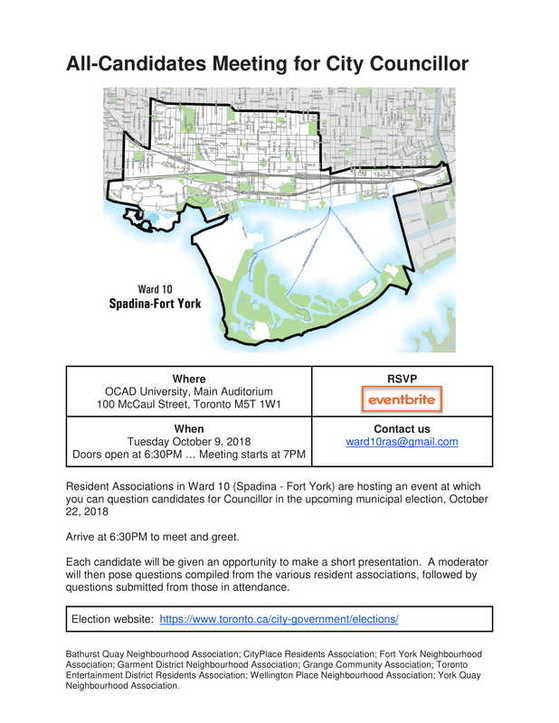
​On May 1st, at a meeting of the Planning and Growth Management Committee, the long-awaited TOcore report (here, as submitted) was adopted with amendments (here, the amendments).  The amended Downtown Plan will be submitted to City Council at its May 23-25 session.
​
The GDNA gave input into the May 1st meeting by way of this comment from Valerie, cc Joe Cressy’s office, as follows:
The curb has become the most contested part of city streets.  "Where is my Uber, UPS, PizzaPizza support to stop?"
As someone who has raised this issue at numerous community consultation meetings and OMB hearings, I was hoping to see something in the Downtown Plan under 8. Mobility ... Parking and Curbside Management.
Existing buildings (both residential and commercial) must somehow adapt to the new reality of bike lanes, e-commerce, and ride-hail services.  But City Planning, with input from Transportation Services, needs to assess new development on the basis of its ability to "internalize" rather than "externalize" such activity ... in other words assess its ability to accommodate UPS/Uber/PizzaPizza pick-ups and drop-offs within its own site rather than adding to curbside chaos.
Could this translate into policy with additional wording (in italics) such as this?
8.28.  Pick-ups and drop-offs, loading and parking activity shall be encouraged off-street wherever reasonable and practical to free up curbside space.  New development applications in the downtown shall be assessed from the perspective of internalizing rather than externalizing curbside activity.
Cressy’s office worked hard to incorporate various resident and stakeholder comments into the long list of resultant amendments.  The short italicized amendment suggested by Valerie was revamped as a new policy to read as follows:
​Development will generally be required to limit and/or consolidate vehicle access points and will be encouraged to provide facilities for passenger pick-up/drop-off, loading and parking in off-street locations and/or within building footprints, in order to free up on-street curbside and public realm space and improve safety of pedestrians and cyclists.
That’s one for the good guys!
0 Comments

An inventory of development applications in our community

4/17/2018

0 Comments

 
Here is a list of applications we are following and where in the application cycle each one sits.  Six applications have filed with the OMB:
Picture
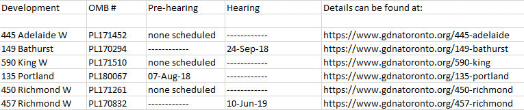
Of the remaining four applications in our catchment, two were submitted only recently and, if they are contested at all, will need to appeal to the new LPAT (Local Planning Appeal Tribunal) rather than the OMB.  Both these applications make their "debut" at a Community Consultation Meeting scheduled for April 30th.
Picture
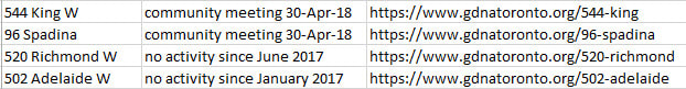
Not included on either list are developments that have already been approved either by the City (ie Waterworks) or by the OMB (ie the James).  379 Adelaide is not listed because an application has not yet been submitted ... what we saw last summer was a pre-application presentation only. 

Then we follow other proposals that are actually outside our catchment but located on the periphery:
Picture
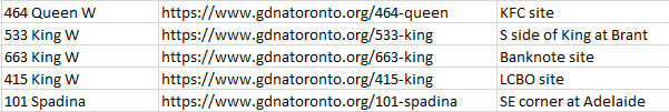
And lastly we follow some big developments which, though several blocks away, promise to affect our neighbourhood substantially:
Picture

P.S.

Urbantoronto.ca does an excellent job of keeping tabs on developments in Toronto in general.  This article really demonstrates how much activity there is in our larger neighbourhood (Simcoe/Bathurst/Queen/Front):
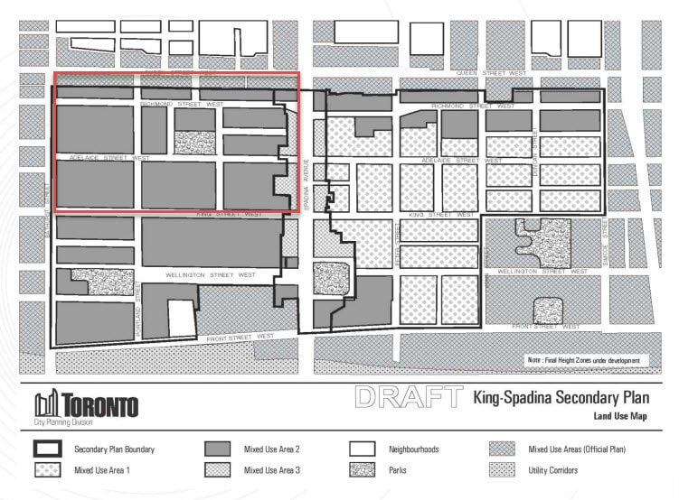
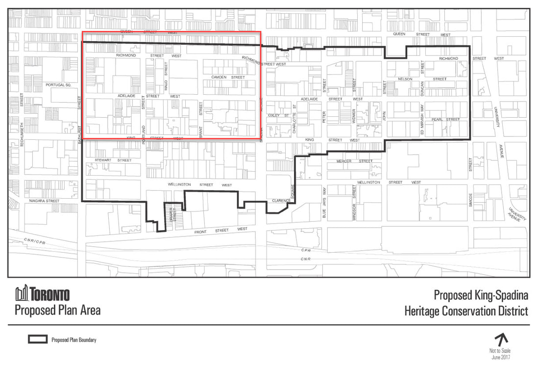
http://urbantoronto.ca/news/2018/01/growth-watch-2018-entertainment-district
0 Comments

Update on Planning Initiatives Involving our Neighbourhood

11/4/2017

0 Comments

 
TOCore, King-Spadina Secondary Plan, King-Spadina Heritage Conservation District ... yes, we are involved in all these initiatives.  And all three initiatives are moving quite quickly and in tandem.

​
TOCore
​

The TOCore Proposed Downtown Plan was adopted without amendment at the City Council session on October 2, 2017.  This means that the principles espoused therein were ratified by the City but stakeholder and public consultation (open houses, round-table discussions, public meetings) are still required before the Plan is "passed", presumably mid-2018.  Nevertheless, even in its "proposed" form, it will be something to work from when assessing current and upcoming development applications. 
Here is are links related to the Plan in question:
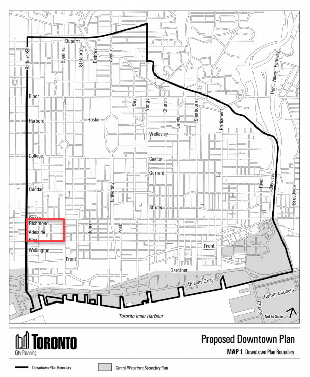
  • the presentation to City Council.   
  • the actual text of the Plan.
  • City Council agenda item PG22.1.
  • TOCore's webpage with updates and links.​  
Picture
King-Spadina
​Secondary Plan


​Attached here are the presentation slides from a public meeting held October 11, 2017.  Draft policies will be submitted in a report to Community Council in November, final policies to Community Council in January then to City Council in February.
Comments should be addressed to Lynda Macdonald (Acting Director of Community Planning downtown) whose contact information is on the last slide. 
The content of the K-S Secondary Plan mirrors that of the TOCore Proposed Downtown Plan.  Boundaries of the Secondary Plan mirror those of the Heritage Conservation District.
Picture
King-Spadina
​Heritage Conservation District


​On October 4th, City Council adopted this item without amendments, the result being By-law 1111-2017, which designates the King-Spadina Heritage Conservation District under Part V of the Ontario Heritage Act.  As one can garner from the By-law notice, there is an expectation that one or more parties may object via the Ontario Municipal Board (OMB).  If no such objection (notice of appeal) is received on or before December 1, the By-law will come into force on December 2, 2017.
Under this By-law, owners of property are required to apply for a heritage permit before demolishing any building in the District or making alterations that are visible from the street (interior work, painting and repairs using the same materials will not require a permit).  New (infill) construction will be required to contribute to the heritage character of the District, as per the District Plan.  If City Council refuses the permit, the applicant may appeal to the OMB.  
Take this link for detailed documentation on the KSHCD. 
Picture
To appreciate the meaning of terms such as "listed" and "designated", "Part V" and "Part IV', Toronto Planning and Development has produced this document of Frequently Asked Questions.

The Ontario Government has two publications that provide additional information on designation:
  • Guide to District Designation Under the Ontario Heritage Act.
  • Guide to Municipal Designation of Individual Properties Under the Ontario Heritage Act.
0 Comments
<<Previous

    Archives

    January 2022
    September 2021
    July 2019
    April 2019
    October 2018
    May 2018
    April 2018
    November 2017
    September 2017

    Categories

    All
    King Street Pilot

Location

Contact Us